
Friday, January 31, 2014


.jpg)


Saturday, January 25, 2014
Tuesday, January 14th to Thursday, January 16th—Our 11th to 13th Cruise Days—Callao, Peru
Tuesday, January 14th to Thursday,
January 16th—Our 11th to 13th Cruise Days—Callao,
Peru
NOTE: Getting internet access while on the ship is becoming increasingly
difficult. We would get better reception if we posted our narrative and photos
while we were in port, but in that case, we want to get out and see things—not
spend our time in an internet café. So we will post on this blog as often and
as best we can, but we will not be able to post as many photos as we would
like—it takes too long to upload them! We will undoubtedly get behind on
postings, but we will eventually catch up.
After
leaving Manta, Ecuador at about 11:00 PM on Saturday, January 11th,
we had two full sea days cruising south along the western coast of South
America before reaching Callao (pronounced “kai-yow”), Peru at about 7:00 AM on
Tuesday, January 14th. We were to spend two full days, and one half
day, docked in Callao--in part to allow time for those who chose to take a 3
day/2 night overland excursion to Machu Picchu. Although we would love to visit
Machu Picchu one day, we chose not to go this time since we already had planned
overland excursions in both China and Africa.
Callao, Peru,
was a stop we were very glad to have made, but are not anxious to repeat. This
is partly due to the fact that we didn’t do our “homework” before our visit. We
had assumed that Callao—even though it was close to Lima—would be similar to
Manta, a small, coastal fishing village. In fact, Callao is a suburb of Lima—a
city of 7 million people. And along with a city of that size comes heavy, heavy
traffic, people who are in a hurry crowding the streets, and of course
seemingly endless construction sites.
On our first
day in Callao/Lima, we had planned a 4 hour excursion titled “A Stroll through
the Plaza de Armas.” Plaza de Armas is a part of the historic center of Lima,
and contains architecture from the 1600’s—but we saw much more than just the
Plaza de Armas. After fighting traffic in a bus for about 45 minutes, we drove
by the plaza of San Martin, walked by and/or into at least 6 different Catholic
Cathedrals/Convents/Monasteries (Catholicism is by far the dominant religion in
Peru), walked by numerous government buildings and homes of government officials,
and finished our tour at the Plaza de Armas itself—viewing the Governor’s
Palace and Cathedral of Lima. The “old town” of Lima is famous for the wooden
balconies on its many structures which were very beautiful and unique. And after
our “walk”—it was more like a death march—we stopped for fruit juice
refreshments at a restaurant in Old Town. (We asked for a beer as well—which
seemed to confuse the waiters no end. They kept reminding us that beer was not
paid for by the tour, and we kept telling them we were happy to pay ourselves.
But somehow that message did not translate well, and they kept repeating as did
we. But we finally got our beers!) And we enjoyed the tour very much, but the
term “stroll” in the title was definitely a misnomer—our tour guide wanted to
show us everything—which meant no time for the leisurely
sightseeing/shopping we had hoped for. So we saw many, many wonderful things,
but it was frustrating to pass by shops and sights we would have loved to
explore, but because there was “no time” during the tour we were unable to do
so. And by the time of our return to the
ship, it was “rush hour”, so the traffic was even worse!
For our
second day in Callao/Lima, we had booked an excursion through Cruise
Specialists (the travel agency we booked our trip with) titled “Archeological
Museum, Pachacamac, & Paso Horse Exhibition.” This time, it was an 8 ½ hour
excursion, so we started in a bus about 7:30 AM—once again in heavy traffic.
After about 45 minutes on the road, we reached the Peruvian National
Archeological and Anthropological Museum. There we took a tour of the museum
and viewed pottery, textiles, and other artifacts from the many cultures that
inhabited Peru over the past 4000 years. For the most part, it was fascinating.
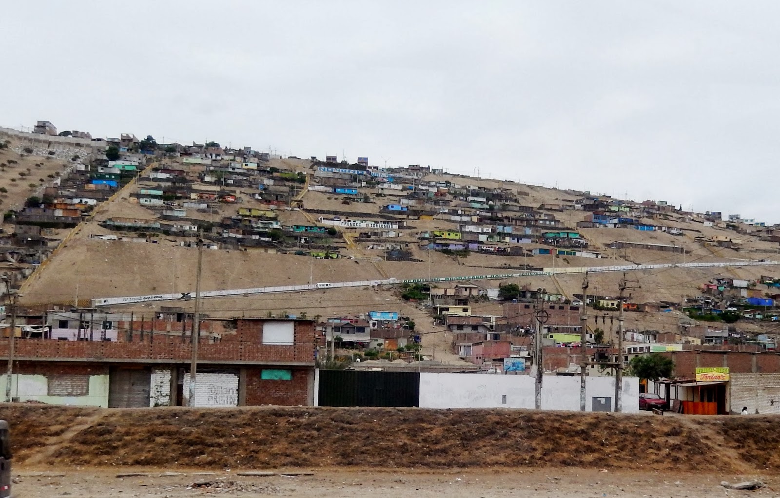
After the
museum, we drove about another 45 minutes through heavily congested Lima to
reach the archeological site of Pachacamac Temple—about 20 miles south of Lima.
Along the drive, we had views of the coastline, and some poverty stricken areas
of the city—including communities of “squatters” in the nearby hills.
Pachacamac
is a huge site encompassing 100 acres or more, and dating from 300 AD with
architecture influenced by 4 different cultures—the last being the Inca who
inhabited the site until the Spanish conquest. In fact, it is believed that when
the Inca king Atahualpa was captured and ransomed by the Spanish, much of the
gold for the ransom came from Pachacamac. Because of its size, a vehicle is
needed to get around to see the entire site, and for us this meant staying on
the bus and listening to commentary from our guide. This was a bit
disappointing—but we were able to get out briefly for some photos.
After
Pachacamac, our bus took us on another 45 minute drive to Hacienda Santa Rosa
which turned out to be the highlight of our trip. When we went inside the walls
of the hacienda we were greeted with a band of horns and drums followed by a
man and a woman who performed three or four different traditional Peruvian
dances, each with its own outfit. During the dance we were served Peruvian
appetizers along with fruit juice and Pizco Sours—an alcoholic drink made from a
Peruvian liquor which tasted like “Whiskey Sours.”
After the
dancing was the horse show featuring the “Caballo de Paso” or “Stepping
Horse”—a breed unique to Peru. Known for its high stepping and very comfortable
gait, the Peruvian Paso horse has become a symbol for the coastal region of
Peru. The horse show first showed a woman in traditional Peruvian dress
“dancing” (i.e. she was on foot while she and the horse danced around each
other) followed by two men and two women mounted on horses that all moved
around in a synchronized gait.
When the
horse show was complete, we had a wonderful buffet lunch of traditional
Peruvian food—absolutely delicious! We finished our meal by being invited into
the hacienda house where we had our choice of many different desserts.
And at this
point, we thought our tour would end. It was 3:00 PM, and a one hour drive back
to the ship. Since the tour was advertised as 8 ½ hours, and we started at 7:30
AM, we should have arrived back at the pier by 4:00 PM. And we wanted to be
back to the ship at that time since afterwards we wanted to take the free
shuttle from the ship to the Shopping Mall next to the Marriott Hotel in
Mirabella (a suburb of Lima, about a 45 minute trip—in traffic), returning on or
before the last shuttle at 7:00 PM. So
we were all loaded on the bus at 3:00 PM, ready to depart, the driver has
started his engine—but wait! One woman on our tour group complained that we had
not been allowed to actually ride the horses as had been advertised in
the tour description! So our guide asked how many people wanted to ride the
horses, and although initially it was just the one woman, eventually 15 of the
18 in our group raised their hand—indicating they wanted to ride the horses too.
We didn’t
care to ride the horses, so we waited—over an hour—on the bus while the others
got their ride. This was particularly frustrating since there had been plenty
of time before and after the meal was served for those who were interested to
ride the horses. But no—they waited until the bus was loaded with people. And
of course this meant that we would probably not be able to go to the mall
afterwards as we had planned.
About this
time we realized that the bus would pass by the mall on its return journey. So
we asked to be “dropped off” so that we could walk to the mall and make our way
back on the shuttle. Our guide very reluctantly agreed, and we were dropped off
about 6 blocks from the mall—only to very quickly become lost. We asked several
people along the way “Where is the Marriott Hotel and the Mall?” Unfortunately,
very few Peruvians speak English. Finally we found a young woman we could
communicate with, and she pointed us in the correct direction. So we replied
with “gracias” and made our way to the mall. Our “6 block” walk was really
about 18 blocks, but we finally made it.
The mall was
below ground and located between the Marriott Hotel and the bluff above the
seashore. It had all sorts of western stores: Nike, Brooks Brothers, North
Face, Tony Roma’s, Steve Madden Shoes, Radio Shack, an Apple Computer store and
more. One would think they were in a mall in the US! And why did we want to get
to the mall? This was our last chance to pick up day to day items (and wine!)
before our journey across the South Pacific to various islands, where those
items would be difficult to impossible to find.
After the
mall shopping, we went up to the Marriott Hotel to catch the shuttle back to
the ship. By this time it was 5:45 PM, and were told the next shuttle would
leave at 6:00 PM—perfect, right? Not so fast! This was rush hour in Mirabella, a
suburb of Lima. So the bus was stuck in traffic and took forever to get to the
hotel, and while we waited, more and more people arrived with the intent to
catch the shuttle. Soon it became obvious that all of the people who were
waiting would not fit onto one bus. So the crowd started “jockeying for
position” to be the first on the bus when it did arrive—very uncomfortable! To
make a long story short, we did make the bus when it arrived—just barely—and we
were the last ones to make it on. By the time we got back to the ship, we were
exhausted.
The next
morning, we had a few hours before the 11:30 AM “all aboard”—but it really
wasn’t enough time to go anywhere. There was a small “Peruvian Market” near the
ship selling souvenirs, and we walked around there for an hour or so. And just
for fun, there was a huge photo of Machu Picchu outside the market which we
posed in front of—pretending we were actually at Machu Picchu!
So we
departed Callao/Lima, Peru, about noon on Thursday, January 16th and
after 3 days there, we were definitely ready to move on. Our experiences in the
Lima area were interesting, but we can’t think of anything we would want to
repeat or go back to see. If we ever returned to the Lima area, we would get
out of the city as soon as possible and visit someplace smaller—such as Cuzco,
Machu Picchu or even some small rainforest settlement. Also, our experiences
there have made us think twice about going on organized bus tours in the
future. In the past, we have had our best experiences when we embraced the
adventure of striking out on our own—and are determined to do much more of that
in the future.
We would
have 4 full sea days heading southwest after leaving Callao before the port of
call that would be a highlight of our trip—Easter Island!


Friday, January 24, 2014


Thursday, January 23, 2014


Sunday, January 19, 2014
Saturday, January 11th—Our 8th Cruise Day—Manta, Ecuador.
After our
Panama Canal transit, we turned south and had one full sea day. At 8:00 AM on
Saturday, January 11th, we arrived at the port on Manta, Ecuador, on
the west coast of South America. All aboard was at 11:00 PM, so we had a full
day ashore ahead of us.
Manta is a
fishing port, and evidence of fishing is everywhere—from fishing boats and
nets, to fish for sale at the market. Like Peru to the south, Ecuador is
divided into three regions running north to south; coastal on the west (where
most people live), mountain in the center (where the capitol city of Quito is
located along with 20,703 foot Mount Chimborazo), and Rainforest to the east.
The official language is Spanish, but English is commonly spoken and the US
dollar is the official currency.
Our visit to
Ecuador was unusual in that Bill and Pat took separate excursions—Bill took the
excursion “Isla Corazon”—a visit to a marine bird sanctuary—while Pat took the
excursion “Tagua Buttons, Panama Hats, & Authentic Manteno Cuisine.” We
will describe our experiences separately. Fortunately, Bill had our friends
Jacob and Margaret George to travel with, and Pat had our friends Don and Lily
Tremblay and Dick and Cynthia Callaway to travel with.
Bill’s
excursion group contained about 28 people—small, which is always a plus—and he
joined his group for a two hour bus trip north to Bahia de Caraquez at the
mouth of a large bay. (“bahia” means “bay” in Spanish.) The bus drive was very
interesting with views of characteristic Ecuadorian flora and fauna along the
way. Upon arrival, we had refreshments of pastry and local fruit juice at an
outdoor hotel garden and then broke into two groups, boarding long, narrow boats
for our trip to Isla Corazon—an island in the bay which is a marine bird
sanctuary.
Since the
island is a protected area, we were required to have a park official on board
whom we picked up at a small pier along the way. This official spoke only
Spanish, but fortunately our guide who was with us spoke excellent English, and
he was very informative.
Isla Corazon
is only a small island (5 miles long and wide?) and is covered with mangrove
trees stretching out into the water. The
best views of bird life are from the water, and as we motored along, we spotted
tropical cormorants, magnificent frigate birds, pelicans, egrets, and blue
herons—both nesting and flying. We even saw a male frigate bird with its red
throat pouch inflated in full display.
After visiting
the island, the boat took us to the city of Bahia de Caraquez where we
disembarked and visited the city’s Museum of Archeology.
The museum
was fascinating—displaying pre-Columbian artifacts of gold, pottery, and
textiles. Ecuador has had many, many cultures over thousands of years, and each
culture had its own unique artifacts—well represented in the museum. The museum
even had a full scale replica of an ancient ocean-going log raft.
After the
museum visit, we took our bus back to the hotel where we originally caught the
boats for the Isla Corazon trip. There we had lunch, and the hotel
owner/operator was an Ecuadorian who had converted to the Hindu faith. As a
result, our meal was vegetarian, and we were served non-alcoholic beer and
fruit juice. But everything was wonderful—including a tofu stew which was
absolutely delicious. Later we learned that this hotel was chosen because it
was deemed “safe” in terms of cleanliness and the unlikely chance of customers
becoming sick from the food or drink.
After our
meal, we began our return bus journey to Manta—which was equally as
interesting. The whole excursion was about 8 hours and was time well spent.
Meanwhile,
Pat took about an hour bus ride to a village where Panama hats were made. While
most folks think that Panama hats are made in Panama, they are actually native
to Ecuador. On the way, the bus stopped at a fishing village, where men, women
and children prepared the boats to go out to fish for tuna and other species.
When we reached the village where Panama hats are made, Pat found it very
interesting to see that women, particularly, spent most of their time weaving
the hats. In order to produce them, women must bend over the hat in progress,
and push down on it. Needless to say, they can only do this for a few hours at
a time.
After the
hat demonstration, we moved on to the tagua button factory. Tagua is vegetable
ivory, produced from the nut of a palm tree.
These trees take several years to grow big enough to produce the nuts,
but once they are large enough, they can produce nuts for many years. The tagua
nut is soft at first, but hardens quickly and is used to produce buttons for
companies such as Tommy Hilfiger and Ralph Lauren. While these companies used
plastic buttons in the past, they have recently become more “ecologically”
minded, and now buy their buttons from Ecuador. Not only are buttons produced,
but also small figures are carved from the tagua nuts. Pat enjoyed finding
several souvenirs to bring home to our grandkids! The whole excursion was about
6 hours and most enjoyable.
Bill and Pat
met up at the pier in front of the ship upon Bill’s arrival from his excursion
(Pat’s excursion was shorter than Bill’s, and she arrived back first.) While at
the Panama hat village Pat received a telephone call from our daughter
Rhiannon, informing us that a tree had fallen on one of our rental houses
during a severe windstorm the night before! So after Bill heard this news, we
both boarded the ship and began dealing with the rental house issue with phone
calls and e-mails. (Some of you may remember that while on the 2012 cruise, a
tree fell on our property in Snohomish, which Matthew had to deal with.)
About 11:00 PM, our ship departed Manta,
Ecuador. We would continue heading south along the west coast of South America
for two complete sea days before arriving at our next port of call—Callao, Peru,
on Tuesday, January 14th. 


Friday, January 17, 2014
Thursday, January 9th--Our 6th Cruise day--The Panama Canal
Thursday, January 9th—Our
6th Cruise Day—The Panama Canal.
The next day
after our visit to Puerto Limon, Costa Rica, we were to traverse the Panama
Canal!
On our 2012
World Cruise, we were fortunate to pass through the Suez Canal—a fascinating
trip through what was basically a long wide, heavily militarized “ditch”—in which there were no locks and we
were at sea level at all times.
The Panama
Canal is very, very different from the Suez Canal. The Continental Divide
mountain range runs the length of Panama, and it would be impractical—if not
impossible—to dig down far enough to produce a sea level canal. Hence, when
coming from the Caribbean (or Atlantic) side a series of locks lift ships from
sea level up to Lake Gatun, the ships travel the length of the lake and the
Culebra Cut, and then two more sets of locks take ships back down to sea level
on the other side.
The Panama
Canal is deceptive. We were traveling from the Caribbean Sea to the Pacific
Ocean, so it is tempting to think that our trip through the canal was from east
to west. But considering the geography of Panama, our journey through the canal
was really northwest to southeast which—to me at least—is counterintuitive (please
see map). Perhaps the easiest way to think of the canal is: “three steps up,
three steps down”—a ship must go through three chambers or locks to get from
sea level up to Lake Gatun, and three chambers or locks to get down from Lake
Gatun to sea level on the other side.
We passed the
city of Colon and entered the approach channel to the canal on the Caribbean
side at about 5:00 AM while it was still dark. At this point, a pilot boarded
our ship to take us through the canal—with the pilot being in charge of
navigation through the canal. We also had an escort of two tug boats—one
leading and one trailing our ship. The pilot and the tugs are requirements for
transiting the canal—it goes without saying that the Panamanian government
doesn’t want any navigational “accidents” while inside the canal!
At about
6:30 AM we entered the first of the three sets of locks—the Gatun Locks. All
three sets have two “lanes” parallel to and operating independent of each
other. This allows two large ships to go through a particular set of locks at
the same time, and theoretically in opposite directions. Each lane of the Gatun Locks has three
chambers and therefore 4 gates—some of which are double gates. We entered the
first chamber at sea level, followed by a closing of the gate behind us. Then
water from Lake Gatun flowed into that chamber, causing the ship to rise to a
higher level. Upon reaching that higher level, the gate in front of us opened,
and we went into the second chamber. This process was repeated, until we
reached the third chamber and the last forward gate opened allowing us into
Lake Gatun.
While the
tug boats assisted us in entering the approach to the locks, they did not
actually accompany our ship through the locks. On shore as we went through the
locks were mechanical “mules” that looked like small railroad cars on railroad
tracks—three on each side of the ship. Each mule had two cables attached to the
ship, and moved along the tracks as we went from chamber to chamber. It was
tempting to think that the mules were pulling the ship through the canal, but
actually they were there to prevent the ship from moving side to side laterally
and colliding with the sides of the canal causing damage.
So we
entered Lake Gatun, and had some time to kill since we could not enter the
Culebra Cut until ships going the opposite direction had cleared. Our ship’s
captain, Captain Jonathan Mercer, first took us over to the dam on Lake Gatun,
and then to the works for the new Gatun Locks. The new Panama Canal Locks—which includes all
three sets of locks—are scheduled to open in 2015 or 2016 and will accommodate
ships of a much greater girth—making the canal more attractive to shipping.
We spent
about 3 hours traversing Lake Gatun, and the views of the islands in the lake
were spectacular. Later, we entered the Culebra Cut—a narrow channel leading up
to the Pedro Miguel Locks. In fact, the Culebra Cut was the most difficult part
of the canal to build. Earth and rock had to be excavated to a depth which
would allow for the movement of shipping, and that included excavating the
Continental Divide mountain range. Not only was the Culebra Cut made before the
canal could be opened, but a channel had to be dredged in Lake Gatun to allow
for shipping. And eventually, the level of the lake itself was raised.
We passed
through the Culebra Cut and moved towards the Pedro Miguel Locks. Along the
way, we passed through the Continental Divide, and under the Centennial
Bridge—built in the early 2000’s to celebrate 100 years of Panamanian independence.
Although the
Gatun Locks were “three steps up”, a single set of locks could not accommodate “three
steps down” because the earth and rock on the southeastern part of the canal
were not as stable as in the north western part— where the Gatun Locks are
located. So there are two sets of locks in the southeastern part of the canal—the
Pedro Miguel Locks which are one step, and further on, the Miraflores Locks
which are two steps.
By the time
we reached the Pedro Miguel Locks, there was a torrential downpour of rain—in
fact photography was very difficult in this section, and most
passengers—including us—took refuge in our cabins. But after we exited the
Pedro Miguel Locks and moved towards the Miraflores Locks, it cleared up, and
we got our best views of the canal. (When we went through the Gatun Locks, it
was 6:30 AM, and quite foggy)
The
Miraflores Locks are interesting because there is a visitor’s center next to
the locks—which was absolutely packed with people the day we went through.
Also, the visitor’s center has a “webcam”—meaning that people from around the
world can watch ships—and people on the ships—go through the locks.
Unfortunately we found out about this too late to let our friends and family
back home to know that the webcam was available.
We departed
the Miraflores Locks about 4:30 PM and made our way through the entrance/exit
channel of the canal, passing under the Bridge of the Americas connecting the
Pan-American Highway. At the end of the channel, we could see the City of
Balboa on our right, and Panama City on our left with its numerous skyscrapers.
And then we had completed our traverse of the Panama Canal and were in the
Pacific Ocean.
This year,
2014, is the 100th anniversary of the opening of the Panama Canal,
and there are numerous celebrations planned for the occasion. Of course, this
was our second trip through the Panama Canal. (Our first was when we extended
our 2012 world cruise after the ship returned to Ft. Lauderdale, and stayed on
board allowing the ship take us home to Seattle via the Panama Canal.) But this
transit was just as special as the first. Much of our day was spent in moving
from one part of the ship to the other in order to get the best vantage point
for viewing and taking photos. At 5:00 AM we were not up to see our entry into
the approach channel (it was still dark anyway!), but we were up for our
passage into the Gatun Locks and were actively moving about from that point on.
For the passage, the foredeck of the ship was opened to passengers where “canal
rolls” (rolls with apricot filling) were available in the morning. An audio narration
was broadcast throughout the ship as we progressed through the canal which was
very helpful in keeping track of where we were and the highlights to see. The map posted on this blog was provided for
each passenger, and is probably the best way to get a sense of the transit, showing
both the original canal—which we went through—as well as the new canal under
construction.
Once outside
the Panama Canal we entered the Pacific Ocean and turned left to go down the
west coast of South America. We would have just one sea day before our next
port of call—Manta, Ecuador, on Saturday, January 11th.


Subscribe to:
Posts (Atom)