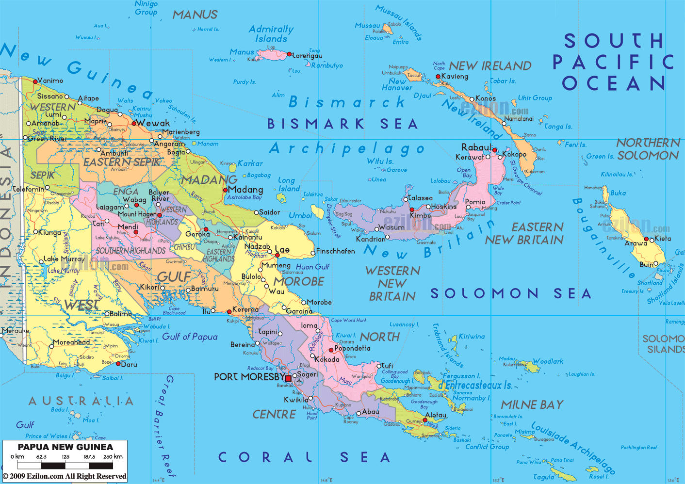
Saturday, August 23, 2014

Friday, February 21st—Madang, Papua New Guinea—Our 48th Cruise Day

Friday, February 21st—Madang, Papua New Guinea—Our 48th Cruise Day

We departed Alotau, Papua New Guinea, at about 5:00 PM on Wednesday, February 19th, and on Thursday the 20th, we cruised northwest through the Solomon Sea and past the islands of Bougainville and New Britain. (It was in the Solomon Sea, southeast of Bougainville Island, that John F. Kennedy’s PT 109 was sunk during World War II. In addition, Bougainville saw very heavy fighting during World War II.) By the early morning of Friday, February 21st, we had sailed into the Bismarck Sea north of the island of New Guinea and reached the northeast coast of Papua New Guinea and Madang Harbor—where we docked at Main Wharf in the town of Madang.

Madang is the name of both a Province of Papua New Guinea, and a town in that Province. The town has a population of about 27,000, and was first settled by Germans in the 1800’s—who were driven out by malaria. Later it came under Australian administrative control. Madang is on Astrolabe Bay which is part of the Bismarck Sea.  (Astrolabe Bay is named for the ship of French explorer Jules Dumont d’Urville—who discovered the bay in 1827.) Madang and Binnen Harbors located in the bay offer protection and safe moorage from the open waters of Dallman Passage and the Bismarck Sea.
In 1942, Japanese forces invaded and captured Madang without a fight. Australian forces recaptured the town in April, 1944, but the town had been virtually destroyed by the occupation and fighting, so it had to be rebuilt. Before, during, and after Japanese occupation, “Coastwatchers”—mainly from the Royal Australian Navy who were living in the area before the Japanese invasion— “watched the coast” in the Madang region in order to give early warning to Allies of the approach of Japanese forces. Coastwatchers consisted of both civilians and military personnel and they performed their task at great personal risk. Coastwatchers made their first sightings of large Japanese “flying boats” off the coast of Madang in December 1941. Today, there is an impressive memorial tower in the town of Madang—which also serves as a working lighthouse—honoring the Coastwatchers.
Most passengers on our ship considered our stop in Madang one of our most forgettable ports. Pat would certainly agree with this assessment, and Bill would as well except for one very special highlight. At this port, we signed up for a Holland America tour that would take us on a boat ride through the Madang Harbor and out into Astrolabe Bay to an “uninhabited island” where we would have a “relaxing day on the beach” with lunch provided. This excursion was particularly attractive to Bill because the information describing the tour indicated that SCUBA diving in the waters around the island was an option. (On board the ship, Bill and about 7 or 8 others formed a “SCUBA Diving Club” and several members of the club, like Bill, chose to go on this tour because of this option.)
When choosing a tour, passengers are really at the mercy of the written description for the tour. And of course this description makes every tour option sound absolutely wonderful.  Most of the time, tours closely match the description and provide good value. But sadly this was not the case for this tour—and when we discovered this it was too late. 
About 8:30 AM, we met our tour group portside and boarded a bus for the 10 minute ride from 
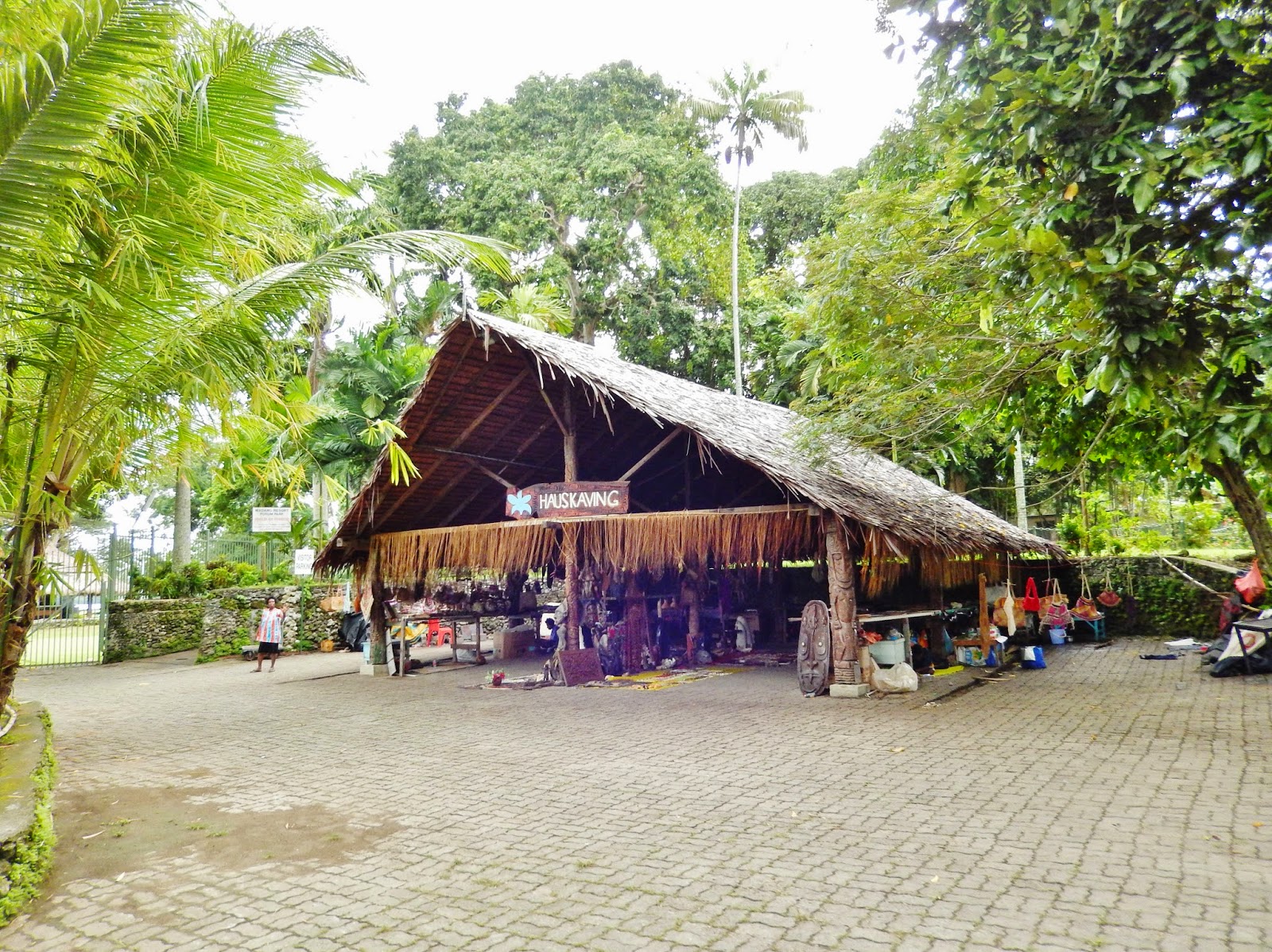
Main Wharf along Coastwatchers Avenue to the Madang Resort. The resort has a variety of activities available, including shops, restaurants, bars, a PADI dive shop, and the “Hauskaving” where woodcarvings and other objects made by locals could be purchased. None of us in the dive club noticed the PADI dive shop at the resort, and we all boarded the boat assuming that dive equipment would be available on board.
And at this point the tour began to unravel. The boat was large (60 feet?) but extremely crowded! And we couldn’t figure out where all of the people had come from—they weren’t all on our bus. But some of them were passengers on the ship. What was going on?
It turns out that the Captain of the ship realized he could make more money if he charged a small fee and allowed people onto the boat who weren’t booked on the tour. And so the boat had a crush of people—most of whom could not find a seat. We were lucky and were able to get a seat at a table with our friends Mary Martinen (a member of the SCUBA club) and her brother Tony. But never were we given any kind of safety briefing—we didn’t even know where the life jackets were. And if this extremely overcrowded boat got into any kind of an emergency situation, the result could have been disastrous!
The trip to the “uninhabited island” took about 45 minutes and we got some good views of the harbor and its islands. But the day was very overcast, and what we saw was hardly spectacular.
We arrived at the island and anchored about 100 yards from the shoreline. And upon arrival at the island, several things became clear:
1.  There was no SCUBA gear available on board.
2.  There was a shuttle boat that would take us from our boat to the shore. But the shuttle held only a small number of passengers, and it was going to take many trips—and much time—to get everyone ashore.  
3. There were copious amounts of “debris” in the water—some from vegetation, some “man made.”
4.  The beach was practically nonexistent, and the small beach areas that were there were rocky and not nice—certainly not somewhere you would want to spend the day!

Bill had brought his own snorkel gear and he—along with come others—chose not to wait for the shuttle boat to take him to shore, but rather to jump overboard off our boat and swim ashore. And this was fine—except that the shallow water had sharp rocks and when he reached the shore, it was nearly impossible to stand up and reach land in bare feet. Fortunately he had put his knapsack containing his aquasox in the shuttle boat, and when the shuttle boat reached shore, friend Tony got them out and threw them to Bill in the water. And so Bill made it to dry land!

While Bill was waiting for Pat to come ashore on the shuttle boat, he did some snorkeling in the shallow water off shore. (Pat wasn’t game to jump overboard and swim ashore like Bill did!) And the snorkel there was one of the highlights of the whole cruise for Bill. Yes the water had floating debris—some of it unpleasant, although we won’t go into details. But underwater it was spectacular! There were hundreds of different varieties of brightly colored fish, unspoiled multi-colored coral of numerous shapes and sizes, nudibranchs in the water and on the bottom, starfish, bright green eels living among the corals and rocks, and large lobster-like crustaceans poking their noses out of nooks and crannies. It was the one dive where Bill really regretted not having an underwater camera. But the real highlight was observing amphiprions—also known as “Clown Fish,” or “Nemo” (from the movie). These fish are about 2-3 inches long and bright orange in color with white circles, patches, and bars. They are beautiful to look at and their behavior is equally spectacular. Amphiprions will live among the tentacles of sea anemones for protection from predators. The tentacles of anemones will not “sting” each other because of chemical compounds on the surface of the tentacle. (Don’t ask us how this works!) Amphiprions swim close to the tentacles in order to extract some of this compound onto their scales which allows them to then shelter within the tentacles and not get stung. So if a predator appears, amphiprions will dive for the nearest anemone and predators cannot pursue them for fear of becoming stung.

This classical behavior of amphiprions is very famous, and in the past, Bill had seen one or two amphiprions near an anemone, but not the behavior as described. However snorkeling at this island showed this in spades. Underwater and about 20 yards off shore there were several large, “dinner-plate sized” anemones each with 4-5 amphiprions nearby. When Bill waved his hands—which the amphiprions considered threatening—they dove for the protection of the nearby anemone. And then—when they perceived the threat was gone, they would slowly come out into the open. Bill had a great time waving his hands to make the amphiprions go into the anemones, waiting for them to come out, and then waving his hands again—over and over. The amphiprions may have become tired of this game, but Bill didn’t and he spent well over an hour “playing” with them. Sadly, there was only a handful of people who snorkeled, and Bill was probably the only one who saw and observed the behavior of the amphiprions.
Eventually Pat was able to get ashore, but it was not a happy place, and she soon wanted to return to the boat—as did almost everyone else. Bill, along with Mary and Tony, stayed as long as we could, with Bill returning to snorkel on the reef several times. Bill was one of the first ones in the water (jumping overboard) and the last one to leave the island—his return by shuttle boat. Most people spent about 15 minutes on the island. Bill was there about 3 hours!
Back onboard the boat, it was time for lunch—barbecued chicken and pasta. But there wasn’t enough for everyone on the crowded boat and most people had to stand while they ate. Fortunately, Mary and Tony were able to get the same table they had before and we joined them, so we were among the few who were able to eat sitting down at a table.
At this point, we were at anchor and everyone was aboard the boat—no one was on the island. After lunch, the Captain reminded us that this was a “whole day” tour and that there was plenty of time for people to go back to the island. But a chorus of people shouted in response: “Just take us back—now!!!” Although Bill had had a great experience snorkeling, most were extremely disappointed and felt their experience did not live up the written description of the tour. And they were not happy about it!
About 1:30 PM we weighed anchor and the boat took us back to its moorage at Madang Resort. The trip back was uneventful and it was still an overcast day. Upon our arrival, Bill and a few others decided to walk back to the ship along Coastwatchers Avenue—a 30 minute walk—while Pat and most of the other passengers took the bus back to the ship.
Bill decided to walk back partly because he wanted to see the woodcarvings and other objects for sale at the “Hauskaving” inside the resort grounds, and partly because he was toying with the idea of walking up the hill—in the opposite direction of where the m/s Amsterdam was docked—to visit the Coastwatchers Memorial Lighthouse.
At the “Hauskaving”, Bill ran into our friends Jacob and Margaret George who told him that the Coastwatchers Memorial was well worth a visit.  The objects for sale at the “Hauskaving”, were interesting—but Bill kept coming back to the idea of “Where am I going to put this?” and ended up just buying some handmade earrings for Pat.
And then things started getting just a little bit uncomfortable. Bill started his walk up to the memorial, but encountered a local who advised him not to go—that there had been a violent encounter between a visitor and a local. Bill initially ignored this advice and kept walking. But then he decided it might not be a good idea to walk into a situation of which he had no knowledge, and therefore turned around and headed back to the m/s Amsterdam. (We later heard that a member of the ship’s crew was knocked off of his bicycle and his backpack was stolen. And this caused a commotion, but fortunately the crew member was not seriously hurt. We do not know if the backpack was recovered or not.)
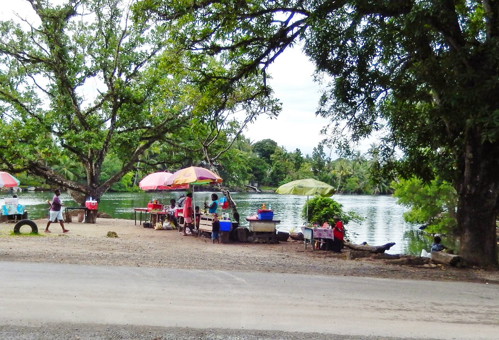
And the walk back was “uncomfortable”—I won’t say scary, but it was uncomfortable. Madang was not like Alotau, where people were friendly and seemed to be genuinely curious about us. Walking back along the waterways of Madang, Bill encountered groups of people—in many cases whole families—selling goods and basically just “hanging out” along the shoreline. It looked as if people were living there out in the open. And it all seemed very strange—what were they doing there? They weren’t all there to sell goods, and there didn’t seem to be any customers. None of the locals appeared friendly, and since Bill was walking alone, most stared at him unsmiling—as if “What are you doing here?” As Bill was walking back by himself, with locals everywhere around him, he remembered that the average Papua New Guinean lives on about US $1.50/day and that he had over US $300 cash in his backpack! So that is why it was “uncomfortable” and Bill made a brisk pace back to the m/s Amsterdam.
Bill arrived back, and just outside the port gate was a “last chance” to buy handmade goods—mainly wood carvings—from the locals who were lined up along the roadway.
There was a huge sign just outside the port gate that read: “Lukautim yu yet long AIDS Noken koap, stap wantaim wanpela tasol o usim kondom” in Melanesian pidgin with “Australian Gavman sapotim” and “PNG National AIDS Council” at the bottom. The sign translates: “Protect Yourself Against AIDS; Abstain From Sex; Be Faithful to One Partner; Or Use a Condom.” And at the bottom “Australian Government Support” It turns out that Papua New Guinea has a huge AIDS problem—having about 70% of HIV cases in the Asia-Pacific sub region.
Back onboard the m/s Amsterdam the grumbling about the disappointment with the tour—a Holland America sponsored tour—continued. Many disgruntled passengers wrote letters and complained to the Shore Excursions Office—which resulted in Holland America doing something it very, very rarely does—give a partial refund of the tour price to everyone who was on the tour. Bill felt a little guilty receiving the refund since he had had such a great snorkeling experience. But he was one of the very few—maybe the only one—who enjoyed the tour.
The m/s Amsterdam departed Madang at about 5:00 PM and headed northwest through the Bismarck Sea. We would have two full “sea days” before our arrival at Yap Island—part of the Caroline Islands of Micronesia—on Monday February 24th.

Friday, February 21st--Madang, Papua New Guinea--Map of Papua New Guinea showing the Solomon and Bismarck Seas and islands.


Friday, February 21st--Madang, Papua New Guinea--Map of the town of Madang, Madang Harbor, and Binnen Harbor.


Friday, February 21st--Madang, Papua New Guinea--Sign outside Madang Resort listing avaliable activities.


Friday, February 21st--Madang, Papua New Guinea--The “Hauskaving” inside Madang Resort where woodcarvings and other objects made by locals can be purchased.


Friday, February 21st--Madang, Papua New Guinea--Our "Uninhabited Island" experience. View from our tour boat. We are about to depart from our moorage at Madang Resort.


Friday, February 21st--Madang, Papua New Guinea--Our "Uninhabited Island" experience. Sailing through Madang Harbor on our way to Astrolabe Bay and the island. There were some nice homes in the harbor. The orange object in the water is a mooring buoy.


Friday, February 21st--Madang, Papua New Guinea--Our "Uninhabited Island" experience. Sailing through Astrolabe Bay on our way to the island. Our ship--the m/s Amsterdam--is on the right.


Friday, February 21st--Madang, Papua New Guinea--Our "Uninhabited Island" experience. The island we visited is the large one on the left. The small one on the right is inhabited.


Friday, February 21st--Madang, Papua New Guinea--Our "Uninhabited Island" experience. The island from our tour boat. Vegetation is all the way to the waterline and there isn't much beach.


Friday, February 21st--Madang, Papua New Guinea--Our "Uninhabited Island" experience. Our tour boat from the island.


Friday, February 21st--Madang, Papua New Guinea--Our "Uninhabited Island" experience. Pat waving as the shuttle boat arrives on the island.


Friday, February 21st--Madang, Papua New Guinea--Our "Uninhabited Island" experience. Swimming in the water closest to the camera is SCUBA Club friend Mary and her brother Tony. The shuttle boat is coming in to pick up passengers to take them back to the tour boat. Some snorkelers are at far right.


Friday, February 21st--Madang, Papua New Guinea--Our "Uninhabited Island" experience. Pat is ashore, but is not happy. Note the debris in the water!


Friday, February 21st--Madang, Papua New Guinea--Our "Uninhabited Island" experience. Pat and others are are boarding the shuttle boat to return to the tour boat. They have been ashore 15 minutes and have had enough!


Friday, August 22, 2014

Friday, February 21st--Madang, Papua New Guinea--Photo of our tour boat from the island shuttle boat. SCUBA club members Max (bald head rinsing off his fins) and Mike (black suit staring at the camera) are on the landing. Notice how crowded the upper story is--not fun!


Friday, February 21st--Madang, Papua New Guinea--From our tour boat and on our way back from our "uninhabited island" adventure. Another overloaded boat! The guy next to the outboard is taking a photo of our tour boat.


Friday, February 21st--Madang, Papua New Guinea--From our tour boat--We are nearly back to Madang Resort; the m/s Amsterdam is in the background.


Friday, February 21st--Madang, Papua New Guinea--A local selling his wares outside the “Hauskaving” at Madang Resort. Our friends, Margaret and Jacob George are looking at a basket for sale.


Friday, February 21st--Madang, Papua New Guinea--View of locals along the shoreline of Madang Harbor. What were they doing there?


Friday, February 21st--Madang, Papua New Guinea--View of locals along the shoreline of Madang Harbor. What were they doing there?


Friday, February 21st--Madang, Papua New Guinea--View of locals along the shoreline of Madang Harbor. What were they doing there?


Friday, February 21st--Madang, Papua New Guinea--Locals selling their wares just outside the port gate. The m/s Amsterdam is in the background. This was our "last chance" to to puchase these items.


Friday, February 21st--Madang, Papua New Guinea--AIDS sign at the port gate with the m/s Amsterdam in the background. AIDS is a HUGE problem in Papua New Guinea--this sign is to heighten awareness.


Friday, February 21st--Madang, Papua New Guinea-Back onboard the m/s Amsterdam-View from our balcony-Locals in their outriggers are looking up, asking passengers aboard the ship to throw them items of value-such as coins.


Monday, August 18, 2014

Wednesday, February 19th—Alotau, Papua New Guinea—Our 46th Cruise Day


Wednesday, February 19th—Alotau, Papua New Guinea—Our 46th Cruise Day

We departed Cairns, Australia, on Monday evening, February 17th, and on Tuesday the 18th, we cruised north through the Coral Sea, out of Australian waters and into the Torres Strait between Australia and the island of New Guinea. By the early morning of Wednesday, February 19th, we reached the southeast tip of the island of New Guinea and then moved westward through Milne Bay, reaching the town of Alotau about 8:00 AM.
 
The island of New Guinea is the second largest island on Earth (Greenland is the largest) with an area of over 300,000 square miles. The southern coastline of New Guinea appears to fit like a “jigsaw puzzle piece” into the northern coastline of Australia and in fact the two were once joined. But flooding after the end of the last ice age created the Torres Strait which separated the two landmasses. The island was first discovered by the Spanish in the 16th century who named it “Nueva Guinea.”
 
The island has a population of over 11 million and is considered part of Melanesia. Politically, the island is divided into (roughly) equal halves: a western half (Indonesia) and an eastern half (Papua New Guinea.) The territories of Papua (southeastern portion of the island) and New Guinea (northeastern portion of the island) were once separate, but became joined together as one country after World War II. Today Papua New Guinea includes not only the eastern half of the island of New Guinea, but also many islands to the east—including New Britain, Bougainville, and New Ireland.
 
Although there are over 1000 recognized languages, the official language is English, with “Melanesian Pidgin” commonly spoken. The currency is the “Kina”  (US $1 = about 2.50 Kina), but US currency is widely accepted. Industries include copra crushing, palm oil production, and plywood manufacturing.

The town of Alotau (population about 15,000) is located at the head of Milne Bay which is at the extreme southwestern tip of the island of New Guinea. It was the site of an important battle between Japanese and Australian/U.S forces from August 25th to September 7th, 1942. Known as the “The Battle of Milne Bay”, this was where the Japanese suffered their first land defeat of World War II. The battle resulted in about 700-750 Japanese deaths, and about 180 Australian/U.S. deaths. Throughout the town and the surrounding area of Alotau there are memorials to this battle.
 
Alotau is definitely not a common stop for cruise ships. The largest wharf in town (Alotau Industrial Wharf) could barely accommodate us and when moored, the bow of our ship stuck out into the bay. Upon going ashore, it was very clear that the locals were not geared up for tourists—which in many ways was very nice. We decided to make this an “easy day”. We had toured hard at the three ports in Australia and had had only one “sea day” between there and our arrival at Alotou. So we didn’t sign up for any tours and decided to just go into town and see where chance might take us. An old city bus was available as a “free shuttle” to take us on the 10 minute journey into town, so we took advantage of that.

But the first thing we noticed when we got off the m/s Amsterdam was the temperature—it was hotter in Alotau than at any port we had visited thus far on our trip! So we initially thought we would take the shuttle into town, make a quick look around, and then return to the ship to cool off. (It turns out it didn’t work out that way—please read further!)

The shuttle dropped us off at Memorial Park near the Town Center, and the first thing we noticed was that wood carvers from the Trobriand Islands (north of New Guinea) had set up stalls under a thatched shelter and were selling the objects they had created. And their wood carved objects were beautiful—carvings from the Trobriand Islands are renowned for being among the best in the world! Unfortunately, although we were tempted, we didn’t buy anything—we have limited house space and were very near our “art object limit.” Afterwards we walked through Memorial Park where there were informational signs describing the 1942 “Battle of Milne Bay.”
 
After that, we were about to return to the ship, but we ran into a friend who told us that we just had to see the Alotau Main Market. So despite the heat, we walked a few hundred yards into town and to the market. And it was well worth the effort. The market consisted of stalls with fruit and vegetable produce as well as seafood being sold. And the colorful produce included items unlike anything we had ever seen. It was very clear that this was a working market—not a tourist destination. Many of the sellers must have wondered what in the world we were doing there—we looked about as “un-local” as two people could get! But the highlight of our visit to the market was seeing families with children—there aren’t any children on our cruise ship so seeing local children on shore is always special. 

Alotau has an excellent supermarket called the Papindo Department Store and Supermarket and it is just across the street from the main produce/seafood market. So we crossed the street and the supermarket turned out to be an oasis—it was air conditioned with fans everywhere! We bought some wine and beer, and interestingly had to go outside the building to pick up our purchases. And at this point we made the decision to keep exploring rather than return to the ship—Alotau was starting to get interesting! (Actually, it was Bill who persuaded a reluctant Pat to keep exploring!)
 
If any readers of this blog are ever tempted to take a world trip similar to this one, one piece of advice we would strongly recommend is: “Research your ports of call before departing on the cruise to get some ideas for what you would like to see and do.” And this is especially true if you plan to “go it alone” at a port rather than be part of a tour. We had not done as much research as we wished we would have ahead of time, but after starting our cruise, we did get some information from three main sources:

1.  Prior to our arrival at each port, Barbara—a Holland America staff member—would give 45 minute talks on things to see and do while in port. Bill always attended these talks and took notes.
2.  Prior to arrival at each port, Holland America would provide a map and information sheet on what to see and do. Unfortunately the information sheet was very brief, but it did have some useful information.
3.  Holland America has their own sponsored excursions which are described in a booklet. And the booklet describes each place that each excursion will visit. So we were able to get some ideas from the excursion book, which we then visited on our own.

So after cooling off and making the necessary purchases at the supermarket, Bill found a taxi and negotiated a price for the driver to take us around the rest of the day. (We think the price was about US $15). Bill had read from the ship’s information sheet that the “Driftwood Restaurant” was a few miles west of Alotau, and thought that might be a good place to spend a relaxing day. But when we arrived, the restaurant was closed, so we headed east, back to Alotau, and this is where our real adventure began!
 
Bill had read in the Holland America shore excursion book that one of their excursions was to the villages of “Ahioma” and “Gehi Gehi” (both to the east of Alotau) and they sounded interesting. So Bill instructed our taxi driver to take us to those villages. Unfortunately, our taxi driver had no idea where those villages were. But he didn’t want to admit that to us for fear that we would get another driver and he would lose his fare. So the driver took us east, out of Alotau and the main road quickly became a dirt road. We had to ford across water that had flooded the road and Pat was becoming more and more nervous. Clearly we were in a remote area that was becoming more and more remote by the minute! But Bill was enjoying the trip—we passed a school with children playing outside, and a Christian Church built in traditional Papua New Guinea style. After about 45 minutes, we met a man walking along the road and our driver asked for directions to the villages we mentioned. He had no idea. Then we came across a woman with children and asked directions—she pointed and said the villages were down a road even more primitive than the one we were on.

At this point, Pat checked, and incredibly we had international phone service! She texted our son Nathan with the message “We are in Papua New Guinea, and Coach has us going to a place even the taxi driver has never heard of.” Nathan’s reply? “Go Coach!” (NOTE: Our children call Bill “Coach” because he coached them in sports when they were younger.)
 
So we followed the directions of the woman we met on the road and soon found ourselves at a single home on the beach. The owner was very friendly, but she clearly had no idea why we were there. And although the excursion book indicated that this was a “seaside village where we could swim in Milne Bay”, there was no village, and the water was far too rough for swimming. So after about 10 minutes, we departed the “village”—we weren’t sure where we had been, but we were quite sure it wasn’t where the excursion book described! And at that point—to Pat’s great relief—we headed back to Alotau.

But our day was not over. Our driver suggested we visit the Turnbull War Memorial—where the original “Airstrip No. 3” was located, where the Japanese first landed on the island, and where some of the fiercest fighting took place. This was west of Alotau, so upon reaching the town, we once again passed through and traveled about 20 minutes west to the memorial.

The memorial was very moving—it was located where so many Australian and U.S. soldiers lost their lives to keep the airfield open, which was crucial to the success of the battle. But by now that day was starting to wind down—all aboard was at 4:30PM—so we decided to take in just one last sight—the view of Milne Bay and Alotau from “Top Town”—located in the hills above Alotau.

And we were on our way there when Bill had an inspiration of lunacy. Everywhere we went in Alotau we saw locals—especially men—chewing “betel nut.” Betel nut comes from the fruit of the Areca Palm Tree and inside is a “nut” (which isn’t really a nut) that can be chewed along with calcium hydroxide. (Calcium hydroxide is also known as “slaked lime” and is made by heating coral--which is composed of calcium carbonate.) Often the mixture can be flavored with a variety of spices—some of which act as an astringent. But the most characteristic feature of betel nut is that it makes the saliva and teeth of the person who chews it turn blood red. And why would someone want to chew betel nut? Apparently it acts as a mild stimulant which the locals refer to as a “spark.”
 
So of course Bill had to try betel nut. He asked our driver to stop at one of the many roadside stands (which were Alotau’s version of a “7-11”) and secure what we needed for the betel nut experience. (Pat wasn’t game to try.) The first step was to bite through the green fruit to get to the “nut” inside. Bill did this, and was then given a thimbleful of white, powdered calcium hydroxide and a spice that looked like a half of a green bean—only with a “braided” surface. (Bill didn’t know then and still doesn’t know what this “spice” was!) The next instruction was to chew the “nut”, the white powdered calcium hydroxide, and the mystery spice all together. (We are sure it will surprise no one that this mixture has been shown to be carcinogenic!) Bill followed the instructions carefully and began to chew. The first thing he noticed was the horrible taste—truly disgusting! And then his saliva, lips, and teeth turned blood red as predicted. (Pat couldn’t resist taking a photo!) But where was the “spark”? Initially Bill didn’t feel anything. However after a couple of minutes, the spark did indeed come—but it was more like a sledge hammer over the head! Bill’s head was spinning, his heart was racing and he felt like he had just downed a bottle of whiskey. He spit out the betel nut mixture and barely had the wherewithall to get back to the taxi. Actually it was a bit scary—when would he “hit bottom”? How long would he feel like this?

Even our taxi driver started to become a little scared—what was he going to do with a passed out American three times his size? Fortunately Bill felt better and better as we drove to “Top Town”, and within a half hour the effects had greatly dissipated.

We enjoyed the views from Top Town—especially our ship at dock in Milne Bay and Alotau Primary School. But after a few minutes it really was time to get back to our ship—it was starting to get close to “all aboard” and who knows how or when we would get back to our ship if we missed its departure?
 
When we left the ship that morning, our intent was to spend just an hour or so ashore and to make it a simple and relaxing day. But we did much, much more and we are glad we did. Alotau is a town that is rarely visited by cruise ships, and as a result, the locals are much less jaded and far more genuine than in other places. And for us, that is what travel is all about.

Our ship departed Alotau at about 5:00 PM. We would have one “sea day” sailing north through the Solomon and Bismarck seas before our next port of call on the north side of the island—Madang, Papua New Guinea, on Friday February 21st.
 

Wednesday, February 19th--Alotau, Papua New Guinea--Map showing the island of New Guinea and it's location in the Pacific Ocean.


Wednesday, February 19th--Alotau, Papua New Guinea--Political Map of Papua New Guinea showing the locations of Alotau and Madang--both of which we visited.


Wednesday, February 19th--Alotau, Papua New Guinea--Map of Alotau.


Wednesday, February 19th--Alotau, Papua New Guinea--20 Kina note and 10 Kina coins. (Front)


Wednesday, February 19th--Alotau, Papua New Guinea--20 Kina note and 10 Kina coins. (Reverse)


Wednesday, February 19th--Alotau, Papua New Guinea--Docked at Alotau Industrial Wharf. Notice the blue mooring lines tied to shore and how the bow of the ship sticks out into the bay.


Wednesday, February 19th--Alotau, Papua New Guinea--Docked at the Alotau Industrial Wharf.


Wednesday, February 19th--Alotau, Papua New Guinea--Sanderson Bay where fishing boats are moored.


Wednesday, February 19th--Alotau, Papua New Guinea--Trobriand Islanders selling their wood carvings near the Australian War Memorial in Alotau.


Wednesday, February 19th--Alotau, Papua New Guinea--Children at the Australian War Memorial.


Wednesday, February 19th--Alotau, Papua New Guinea--Milne Bay and the m/s Amsterdam (left) from the Australian War Memorial.


Wednesday, February 19th--Alotau, Papua New Guinea--Pat in front of an informational sign at the Australian War Memorial. It was HOT!


Wednesday, February 19th--Alotau, Papua New Guinea--Alotau Main Market.


Wednesday, February 19th--Alotau, Papua New Guinea--Alotau Main Market--Produce for sale!


Wednesday, February 19th--Alotau, Papua New Guinea--Alotau Main Market--Produce for sale!


Wednesday, February 19th--Alotau, Papua New Guinea--Alotau Main Market--Woman and child.


Wednesday, February 19th--Alotau, Papua New Guinea--Alotau Main Market--Produce for sale! Notice the woman outside the shelter at bottom right. She needs an umbrella for protection from the sun!


Wednesday, February 19th--Alotau, Papua New Guinea--Alotau Main Market--Seafood for sale!


Wednesday, February 19th--Alotau, Papua New Guinea--Alotau Main Market--Seafood for sale!


Wednesday, February 19th--Alotau, Papua New Guinea--Papindo Department Store and Supermarket in Alotau. There were lots of clerks on hand to help customers!


Wednesday, February 19th--Alotau, Papua New Guinea--A small roadside market--Papua New Guinea's answer to a "7-11." We would return to this stand later in the day for Bill to have a "Betel Nut Experience."


Wednesday, February 19th--Alotau, Papua New Guinea--On our "Unknown Village Adventure." A school with children playing outside. The school is the green and white building behind the brown roofed "shed."


Wednesday, February 19th--Alotau, Papua New Guinea--On our "Unknown Village Adventure." A Christian church near the school with a traditional style roof.


Wednesday, February 19th--Alotau, Papua New Guinea--On our "Unknown Village Adventure." Beach in front of the single house that was to be the "village."


Wednesday, February 19th--Alotau, Papua New Guinea--Bill and our taxi driver on our "Unknown Village Adventure." We had just reached the single home that was supposed to be the "village."


Wednesday, February 19th--Alotau, Papua New Guinea--House on stilts we saw during our "Unknown Village Adventure." Notice the laundry hanging underneath the house.