Sunday, March 23, 2014

Saturday, February 8th—Our 35th Cruise Day—Kuto, Ile des Pins, New Caledonia.

Saturday, February 8th—Our 35th Cruise Day—Kuto, Ile des Pins, New Caledonia

Our ship departed Noumea, New Caledonia, about 7:00 PM on Friday, February 7th, but didn’t travel far. By 8:00 AM on Saturday February 8th, we were anchored in Kuto Bay off “Ile des Pins” (Isle of Pines), New Caledonia.

Ile des Pins is a small island just off the southern tip of Grand Terre—which is the largest and most populated island in the New Caledonia island group. The first European to visit the island was Captain James Cook in 1774 during his second voyage to New Zealand. Cook gave the island its name after seeing the tall native pines (Araucaria columnaris)—a relative of the “Monkey Puzzle” tree—which were unlike other trees he had seen in New Caledonia. He never disembarked onto the island, but since he saw signs of inhabitance (smoke), he assumed it was inhabited.

In the 1840s Protestant and Catholic missionaries arrived, along with merchants seeking sandalwood. The French took possession of the island in 1853, at which time the native Kunies opted for the Catholic religion. In 1872 the island became a French penal colony, home to 3,000 political deportees from the Paris Commune.

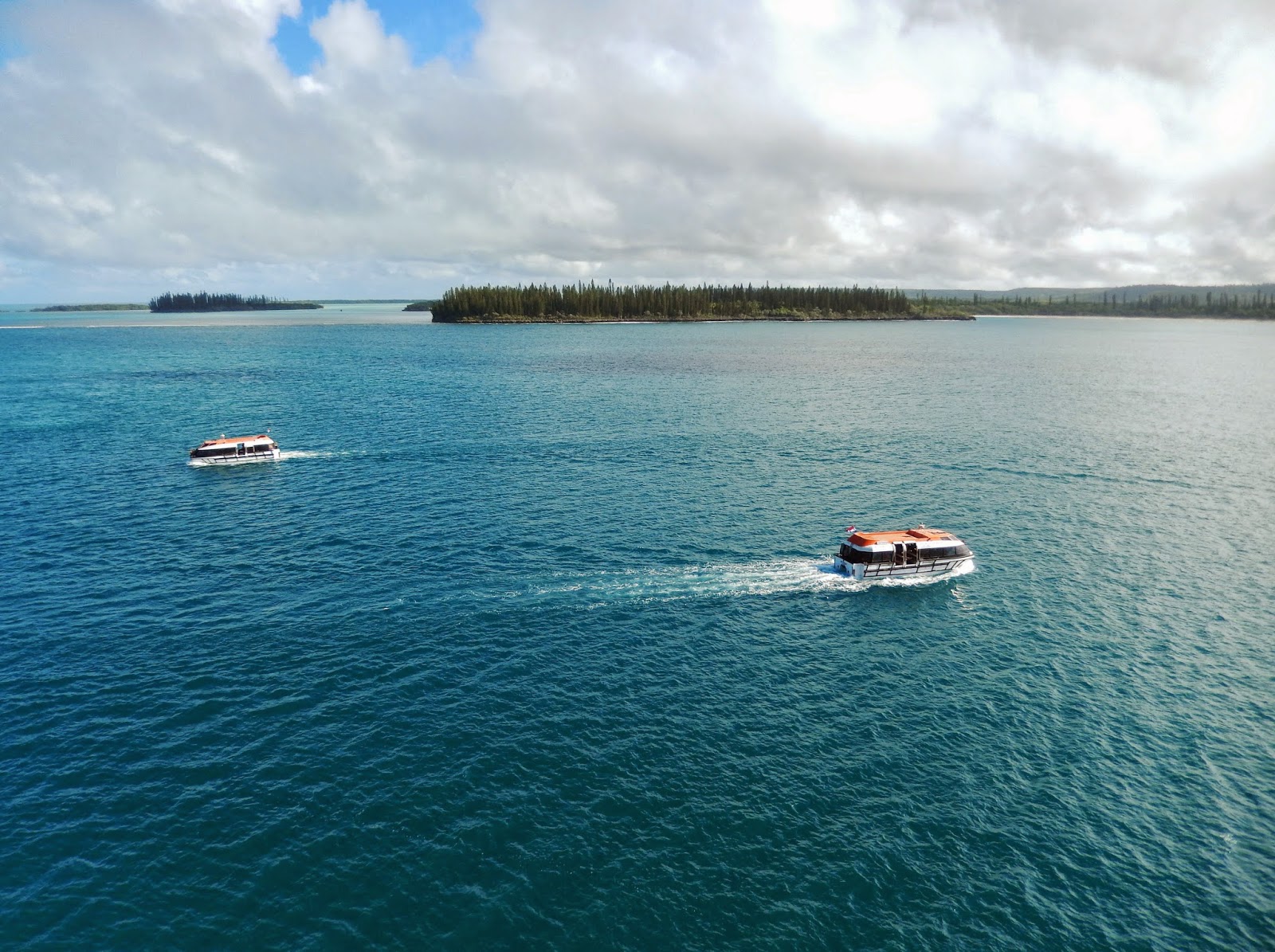
Since we were anchored, this was a tender port—meaning we had to take a tender (which doubles as a life boat) from our ship to a small dock on shore. This was also the last chance we would have to share a port with our friends Al and Erica Wehrle, since they would depart our ship and return home to the U.S upon arrival in Sydney, Australia. We once again decided to tour this port “on our own” and not take a tour organized by Holland America. Exploring a port on our own might mean we don’t see quite as much, but what we do see is our own choice and at our own pace. And on our own there is always the possibility of serendipity—of discovering an unexpected gem that we wouldn’t have seen otherwise.  “Last Tender” was at 2:30 PM, so we wanted to get onto the island early and make the most of our time there.

We, along with Al and Erica, took an early tender, and were on the island by about 9:00 AM. As we walked down the dock of the tender port and into the tiny town of Kuto, we were greeted with the traditional dance, costumes, and music of the Kanak—the indigenous New Caledonians. (Total population on the island is about 2,000 people.) This was a wonderful start to our visit and brought home the point that this really was an exotic place far from home.

On shore near the dock were stalls where the Kanak (most of the inhabitants of Ile des Pins are Melanesian Kanak) were selling sarongs, wood carvings, and other trinkets—similar to the other islands in the South Pacific we visited. We took a quick look but didn’t buy anything—we really didn’t want to come home with suitcases full of souvenirs like we did after our 2012 cruise—and then noticed a beautiful beach and hotel on Baie de Kuto (Bay of Kuto) which was within walking distance to the north. We made note that this would be a good place to end our day and then proceeded to walk up the hill and out of the town of Kuto—signs in town indicated that a gift shop was in that direction. We reached the “gift shop”, which was really was just more outdoor stalls selling the same stuff as we saw down by the dock.

We decided to go back down the hill by a different path, but we, along with others quickly met with an obstacle. On the road down was a bull tethered to a pole with a long chain. And the bull was ornery and not inclined to let us pass—he even demonstrated the classic behavior of “pawing” at the ground with his front hoof. A few people—including Al—ran quickly by the bull when its attention was distracted elsewhere, but most of us were not quite so fleet afoot and chose to wait out of reach and contemplate our options. Fortunately, the bull’s owner soon came by and forced it back into its field with a few bangs over its head. In retrospect, the bull was most likely enjoying his game of terrorizing tourists!

Safely past the bull, we returned to Kuto and saw some vendors offering independent tours. The four of us plus another couple from New Zealand chose one that would take us to see some of the local highlights, and for about $10 each, we were off in a van for a one hour tour that really turned out to be two hours.

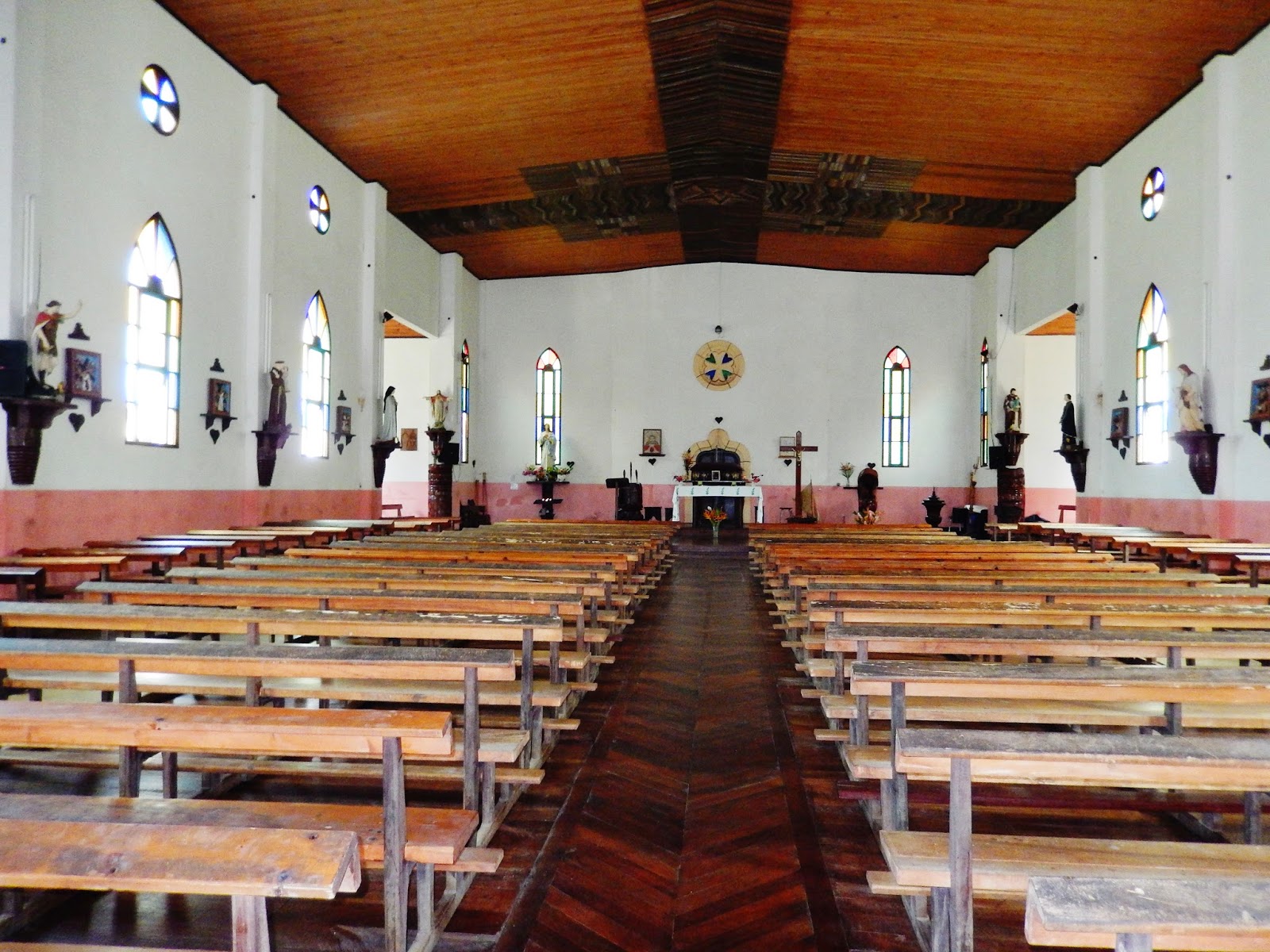
Our tour took us east along the coast of the island from Kuto to Vao—the largest town on the island. Along the way, we stopped for views and photos—including “Brush Island”—which looks like a hair brush with trees at one end and a handle at the other. In Vao, we saw the Mayor’s office and the historic and beautifully preserved Catholic Church—Notre Dame de l’Assomption--made entirely of wood. Yards and gardens around the town contained driftwood sticks and logs that had been carved with faces and stuck vertically into the ground, and fences—also made of driftwood—had fence posts connected at the top with rope—quite unique and something we had never seen before.

After visiting Vao, we continued on to Baie de St. Joseph (St. Joseph’s Bay) and had some beautiful views of the bay and traditional sailing outriggers made from the local pine—also called Kohu. Further on, we reached Baie de Maurice (Maurice Bay), stopping at the St. Maurice Memorial—a commemoration of the first catholic service on the island and a proud symbol of Melanesian culture and identity.

At this point it was time to start heading back, but before ending our tour, we stopped at the Penal Colony Prison about 1 mile north of Kuto in Ouro. The prison was in ruins, but from what was left, it could be seen that the prisoners had a very stark and harsh existence.

Our tour dropped us off at the restaurant/hotel we noticed earlier--Oure Hotel Restaurant--which was right on the beach at Kuto Bay. We were fortunate to get a table on the deck with a beautiful view of the sandy beach and the bay. And it was a perfect place to have lunch and an adult beverage (beer.) The beer wasn’t cheap ($12/can!), but the setting made it well worthwhile. Later Bill went in for a swim while Pat, Al, and Erica relaxed on the deck.

As time got closer to 2:00 PM, it was time to walk back to the tender port. Along the way, we saw numerous Kanak families cooking and selling wares on the beach—but this time the sales were geared towards other Kanaks rather than tourists. So this gave a brief, but important, window into the Kanak culture.  And along the way we had a view of Kanumera Bay with a beautiful limestone island.

We boarded our tender about 2:00 PM, and it soon whisked us back to the Amsterdam. The sail-away party started at 2:30 PM—in which we fully participated—and we departed Ile des Pins, New Caledonia about 3:00 PM. This was our last South Pacific Island port of call—after departure, we would have two full sea days before our next port of call—Sydney, Australia, on Tuesday, February 11th.

Saturday, February 8th--Ile des Pins (Isle of Pines), New Caledonia--Map of Ile des Pins.


Saturday, February 8th--Ile des Pins (Isle of Pines), New Caledonia--From our balcony--Tenders taking passengers to and from the tender port at Kuto.


Saturday, February 8th--Ile des Pins (Isle of Pines), New Caledonia--Kanak dancers greeting us as we arrive at our tender port at Kuto.


Saturday, February 8th--Ile des Pins (Isle of Pines), New Caledonia--Bull blocking our path near Kuto. Our friend, Al Wehrle made it past safely and is looking back at us.


Saturday, February 8th--Ile des Pins (Isle of Pines), New Caledonia--Office of the "Maire" (Mayor) in Vao.


Saturday, February 8th--Ile des Pins (Isle of Pines), New Caledonia--Notre Dame de l’Assomption Catholic Church in Vao.


Saturday, February 8th--Ile des Pins (Isle of Pines), New Caledonia--Notre Dame de l’Assomption Catholic Church in Vao. Note the beautiful wooden ceiling.


Saturday, February 8th--Ile des Pins (Isle of Pines), New Caledonia--Historic home in Vao. (Sorry--I forgot which one!) Note the carved, upright driftwood posts leading up to the house.


Saturday, March 22, 2014

Saturday, February 8th--Ile des Pins (Isle of Pines), New Caledonia--Baie de St. Joseph (St. Joseph’s Bay). Note the boats with outriggers.


Saturday, February 8th--Ile des Pins (Isle of Pines), New Caledonia--Driftwood and rope fence near Vao.


Saturday, February 8th--Ile des Pins (Isle of Pines), New Caledonia--St. Maurice Memorial at Baie de Maurice (Maurice Bay). Note the carvings on the upright driftwood around the memorial.


Saturday, February 8th--Ile des Pins (Isle of Pines), New Caledonia--Pat at the entrance to the penal colony prison in Ouro (near Kuto.)


Saturday, February 8th--Ile des Pins (Isle of Pines), New Caledonia--Ruins of a prison cell at the penal colony prison at Ouro (near Kuto.)


Saturday, February 8th--Ile des Pins (Isle of Pines), New Caledonia--Bill and Pat at the ruins of the penal colony prison at Ouro (near Kuto.)


Saturday, February 8th--Ile des Pins (Isle of Pines), New Caledonia--Baie de Kuto (Kuto Bay) and beach from the deck of Oure hotel/restaurant. At far right is our ship--the ms Amsterdam.


Saturday, February 8th--Ile des Pins (Isle of Pines), New Caledonia--Oure hotel/restaurant on Kuto Bay from the water. Pat is in the pink top, waving at far left.


Wednesday, March 19, 2014

Friday, February 7th—Our 34th Cruise Day—Noumea, New Caledonia

Friday, February 7th—Our 34th Cruise Day—Noumea, New Caledonia

Our ship departed Lautoka, Fiji, about 5:00 PM on Wednesday, February 5th, again heading west. We would have just one full “sea day” before our next port of call on Friday, February 7th—our 8th South Pacific Island, Noumea, New Caledonia.

We would have two stops in New Caledonia—on the first (Feb 7th) we would be docked at the city of Noumea on the island of “Grand Terre”, and the second (Feb 8th) would be a tender port off the island of Ils des Pins (Island of Pines)—a small island off the southern tip of Grand Terre.

Like Fiji, New Caledonia is part of Melanesia. South Pacific islands are divided into three main groups based on the ethnic origin of the indigenous people:  Polynesia (of which Easter Island, Pitcairn Island, Tahiti, Moorea, Bora Bora, and American Samoa are a part), Melanesia (of which Fiji, New Caledonia, and Papua New Guinea—which we would visit on February 20th and 21st—are a part), and Micronesia (of which the Yap Island Group—which we would visit on February 24th—is a part.)

New Caledonia is about 750 miles east of Australia, and consists of many islands—including Grand Terre (by far the largest island where most of the population is located), the Loyalty Islands, the Chesterfield Islands, Beleb Archipelago, Ils des Pins, and a few remote islets. New Caledonia has a land area of about 7,000 square miles and a population of about 256,000—consisting of a mix of Kanak (indigenous New Caledonians), white Europeans, Polynesians, and Southeast Asians. The capital of New Caledonia is Noumea, which is located on Grand Terre. 

The first British contact with New Caledonia was by Captain James Cook in 1774, but there was little European contact after that until 1840, when sandalwood began being exported. During the mid-1800’s, many of the indigenous Kanak were captured and sold as slaves to work in the sugar cane fields of Polynesia, and France took possession of New Caledonia in 1853. During World War II, the United Stated fleet—which turned back the Japanese Navy in May 1942 at the Battle of the Coral Sea—was based in Noumea, New Caledonia. Today, New Caledonia is a “Non Self-Governing Territory” of France, so once again the “French Pacific Franc (XPF)” is the currency used.

For our visit to Noumea on February 7th, we decided to take a Holland America sponsored tour titled: “Zodiac Ride and Ile aux Canards Beach Break.” Our ship arrived at Noumea at 10:00 AM with “all aboard” at 6:30 PM and since this was a three hour tour starting at 10:00 AM, we hoped to have a few hours after the tour was over to see the town of Noumea--and hopefully get to the beach “Anse Vata”, a 20 minute drive south of Noumea. In fact, we made tentative plans to meet up with our friends Al and Erica Wehrle at at Anse Vata beach sometime in the afternoon after our tour. (NOTE: Cell phone communication between friends who have U.S. based phone service isn’t practical on a remote islands. Therefore meeting places need to be established ahead of time, and we all hope for the best that we will be able to find each other!)

As we arrived at the pier, we were entertained by traditional music and dancing of the indigenous people. It is particularly nice when we dock on the port side—as in this case—since we can easily see any welcoming ceremonies, such as this one, from the balcony of our room (Our room is on the port—or left—side of the ship.) In addition the docking and undocking activities are always interesting—which is one of Pat’s favorite things to watch from our balcony. And from our balcony we could see “Le Petite Train”—a small train with cars for passengers that will drive around the city on roads (not train tracks!) to show tourists the highlights. And right across the road from our port was the Casino Supermarche’ where we could pick up some sundry items. After over a month into our journey, there were some things we needed to get that were not available onboard, so a supermarket was a welcome sight!

We left our ship shortly after 10:00 AM, and met with our tour group shore side. This tour seemed like a good compromise—Bill could go swimming and snorkeling while Pat could find a lounge chair and read her book on the beach. But it should be noted that Pat was not all that excited about the prospect of taking a Zodiac ride to get to the island—she is not a good swimmer and really doesn’t like any boat that is smaller than the ms Amsterdam. The Zodiac started off, and it really was “a thrillingly fast ride,” as advertised. Pat was able to endure the trip (enjoy was too much to hope for!) and after about 20 minutes we were out of the harbor, into “Baie de Dumbea” (Bay of Dumbea) and had reached the island of Canards for our beach break. We had to wade ashore from the Zodiac, but soon found lounge chairs on the beach, and Bill was able to cheer Pat up a bit with a beer and some food from the concession hut!

Canards Island is interesting. In addition to lounge chairs on the beach, the island has bizarre art sculptures and of course great snorkeling. In fact, a sign on the island shows a “snorkeling trail” along white buoys which, when you follow the buoys, has underwater informational signs. So we relaxed on the beach, had some food and beers and Bill went snorkeling while Pat read her Kindle.

And then we saw the yellow “Water Taxi” pull up onto the beach! Pat was more than a little annoyed that we paid good money for a Zodiac ride she didn’t want to take when we could have taken a water taxi with a gentler ride and for far less money—and reached the same island! In any case, Bill walked all the way around the island, and soon it was time to return to Noumea via the Zodiac, which had returned to pick us up.

But we did not notice that the Zodiac had returned, and it had loaded up passengers and began its departure without us! When we finally saw that it was leaving, Bill ran down to the beach and began yelling, waving his arms and jumping up and down (as best he could!) to get the attention of someone on board. Fortunately someone on board did see us, and the Zodiac returned for us, but we found it incredible that no one seemed to notice we were missing—after all, there were only about 10 people on board. How much trouble would it have been to count to make sure everyone was there? Of course if we had been left, we could have taken a water taxi back—which Pat would not have minded at all!

Back in Noumea, we decided to catch a taxi to Anse Vata beach and see if we could meet up with our friends Al and Erica. Unlike other ports we have visited, taxi stands in Noumea seemed to be in just one place—Place des Cocotiers—a park in the center of the city. So we walked the few blocks and soon found a taxi. We have found it best to agree on a price for the taxi before we commit since taxi meters are rarely reliable. In this case, the driver quoted us a reasonable price, and off we went to the beach—about a 20 minute drive.

But as we reached the beach, we realized that the chances of finding Al and Erica were close to zero. Many of the beaches we have gone to on this trip have been small, with only one or two restaurants or bars. Not the case in Anse Vata which had about two miles of restaurants, bars and shops. We picked one that seemed to be attractive—the “Malecon Café” on Promenade Rue Laroque—paid our taxi driver and went inside. Of course Al and Erica weren’t there, but we ordered beer and food anyway, and the café turned out to be a charming French Restaurant on the waterfront.

We were at the café for a little over an hour, and then decided to make our way back to the ship—Pat wanted to do some shopping at Casino Supermarche and we were starting to get close to the all aboard time of 6:30 PM. Our waitress called a taxi for us, but we started to get a little worried when she said the taxi wouldn’t arrive for a half hour. And that was “New Caledonia time”—so who knows when or if it would show up! We went out onto the road to see if we could hail a taxi ourselves, and soon a tour bus came by with passengers and staff from our ship. People on the bus persuaded the driver to stop for us, so we climbed in and were back to our ship in about 20 minutes. Whew! We even had time for Pat to do her Casino Supermarche shopping, and we were back onboard with 10 minutes to spare. (NOTE: If passengers are not on a Holland America sponsored tour and miss the ship, it is their responsibility to get to the ship’s next port of call at their own expense—which most likely means an airplane ticket and overnight accommodations!)

We departed Noumea, New Caledonia, about 7:00 PM and of course there was a “sail away” party to celebrate the occasion. But we wouldn’t travel far. By 8:00 AM the next morning we would be anchored off Ile des Pins (Isle of Pines)—our second port of call in New Caledonia. Ile des Pins is a small island off the southern tip of Grand Terre, and this would be a tender port. 

Friday, February 7th--Noumea, New Caledonia--Map of New Caledonia.


Friday, February 7th--Noumea, New Caledonia--Map of downtown Noumea and the beaches south of town--including Anse Vata where we visited.


Friday, February 7th--Noumea, New Caledonia--From our balcony--Sailing into the port of Noumea.


Friday, February 7th--Noumea, New Caledonia--From our balcony--Pat viewing the city of Noumea and the music and dancing of the Kanak--the indigenous people of New Caledonia--on the pier where we dock.


Friday, February 7th--Noumea, New Caledonia--From our balcony--Kanaks (indigenous New Caledonians) making music and dancing on the pier as we dock.


Friday, February 7th--Noumea, New Caledonia--From our balcony--The town of Noumea with Casino Supermarche' across the street from our pier.


Friday, February 7th--Noumea, New Caledonia--"Le Petite Train" which gives tours around and outside of Noumea.


Friday, February 7th--Noumea, New Caledonia--Our tour group (Pat is in the pink top) and guide getting ready to board a Zodiac for our trip to "Ils aux Canards" (Canards Island). The ms Amsterdam is in the background.


Friday, February 7th--Noumea, New Caledonia--Pat on our Zodiac trip to "Ils aux Canards" (Canards Island)--She isn't too sure about the whole thing!


Friday, February 7th--Noumea, New Caledonia--Our Zodiac trip to "Ils aux Canards" (Canards Island)--We are in the harbour and on the other side of the bridge shown is “Baie de Dumbea” (Bay of Dumbea).


Friday, February 7th--Noumea, New Caledonia--Approaching "Ile aux Canards" (Canards Island) from our Zodiac. In the photo you can see the red umbrellas on the beach and the central food and beverage hut.


Friday, February 7th--Noumea, New Caledonia--Signpost with map on Canards Island showing the "snorkeling trail."


Friday, February 7th--Noumea, New Caledonia--Pat relaxing on the beach at Canards Island.


Friday, February 7th--Noumea, New Caledonia--The beach--and water taxi--at Canards Island.


Sunday, March 16, 2014

Wednesday, February 5th—Our 32nd Cruise Day—Lautoka, Fiji

Wednesday, February 5th—Our 32nd Cruise Day—Lautoka, Fiji

We left Pago Pago, American Samoa, about 5:00 PM on Saturday, February 1st heading west. We would have two full “sea days”, and arrive in Lautoka, Fiji, at 8:00 AM on Wednesday, February 5th. One might think it was "three full sea days", but we crossed the International Dateline, and February 2nd didn't exist for us! All aboard was at 4:30 PM, so we would have a full day on the island.

The country of Fiji is a republic consisting of over 800 islands, about 7000 square miles and a population of over 900,000. We would be visiting Viti Levu, the largest island and the one with the greatest population. Our ship was docked at a pier in the town of Lautoka on the west coast of Viti Levu.

Although Fiji has been inhabited by indigenous people for thousands of years, the first known visitor from Europe was Abel Tasman, a Dutch explorer, in 1643. The islands were later visited by James Cook in 1774, and William Bligh is given major credit for the discovery and recording of the islands—after the mutiny on the Bounty—when he visited the islands in 1789.

Today the island population consists mainly of native Fijians with a very high percentage of ethnic Indians. In general, the Indian Fijians have a higher percentage of business ownership and wealth in comparison to the Native Fijians—which has led to some considerable unrest. Fortunately we did not see any evidence of this during the short time we visited.

For our visit to Fiji, we again decided to again “do it on our own” rather than take a tour organized by our ship. And we also decided to spend the day with our friends Al and Erica Wehrle as we had done in American Samoa a few days earlier.

It was very, very hot and humid on the day we visited, and the prospect of intense touring was not particularly attractive. So we decided to make this a “low key” day without hard charging to try to see as much as possible. Al and Erica wanted to see the “Garden of the Sleeping Giant”, so we decided to negotiate for a taxi (Fiji was one of the many places where bargaining is expected and necessary) and head out in that direction—which was south of Lautoka.

Our journey to the gardens wound along a beautiful coastline and we were just a few miles north of the city of Nadi when we turned inland. On our left, we passed Sleeping Giant Mountain whose peak appears to show the profile of a giant sleeping on his back. 

The gardens, at the base of Sleeping Giant Mountain, were founded and developed by the American actor Raymond Burr—of TV’s “Perry Mason” fame—in 1977 to house his orchids. Inside the gardens are hundreds of different types of orchids, along with other types of plants, a walking path with a bridge, and a small lake covered in lily pads. There is even a small, vegetation-enclosed, “sanctuary” at the top of a rise where Raymond Burr used to sit and meditate. Our tour of the garden was an interesting walk, but was not sheltered from the sun—which was bearing down upon us. Al turned back shortly after beginning our walk to seek some shade and shelter, but Bill, Pat, and Erica continued the tour around the garden—led by a guide, provided as part of our admission.

After our visit to the garden, we considered having our taxi driver take us to some other sights: the Laukota Sugar Mill, Vitigo Village in Lautoka, the market at Nadi, Saweni Beach, Vuda Lookout, Denarau Mall or one of the small islands surrounding Viti Levu—such as Tivua or Savala. But we didn’t have time (or energy due to the heat!) to do everything, so we settled on driving back towards Lautoka and stopping at Viseisei Village along the way.

Viseisei Village is a traditional Fijian Village located where legend says the “first landing” of the original Fijians occurred. (Fijians claim to be descendants of the Lutunasobasoba people.) After a short stop for a photo at a restored traditional house, we asked our taxi driver to take us to a “nice resort where we could have a beer and take a swim.” So he took us to the First Landing Beach Resort, and we were delighted! Pat and Erica immediately went and had full body massages, while Bill and Al enjoyed a beer and some food on a deck overlooking the beach.

After an hour, the girls joined the boys—who by this time were on their second or third beer. Bill went for a short walk across a bridge onto a small island that was part of the resort, followed by a swim in the ocean where he was joined by Erica. Then we discovered a beautiful swimming pool on the resort grounds. We all took a swim, and found that several of the ship’s staff—including our cruise director Gene--were there as well. (In our experience, if you visit a place where the ship’s staff visits, you are in the right place—ship’s staff have the inside information on where to go!)

After about an hour of swimming and drinks at the pool, we made our way back to our taxi and driver (who had been waiting for us!) and returned to the ship. Al and Erica had had enough for the day, but we decided to take the free shuttle into Laukota to be dropped off at Jack’s Craft Emporium on Nede Street. We took a quick look inside the emporium, and then walked down Nede Street to Naviti Street—which seemed to be the “main drag” through town. On Naviti Street, we were surprised—and delighted—to see a sign for “MoneyGram”—a business that will wire money long distance. Our son, Nathan, works for MoneyGram in Dallas, Texas and in his words “We are everywhere.” Finding MoneyGram on Easter Island and Fiji seems to prove his words true.

On Naviti Street, Pat found a few sundry items to purchase, but the shopkeepers would only take Fijian Dollars, so we had to change some money. Changing money is always a guessing game since if you change too many US$ into local currency, you will be forced to change the leftover back, and lose in the exchange. But if too few US$ are exchanged, you run the risk of having to go back to change more money—which takes time. Suffice it to say that Pat had to go to the money exchange and wait in line twice within 30 minutes. 

After a short time in Lautoka, we caught the shuttle bus back to our ship—we were hot, tired and sweaty, and wanted to save our strength for the sail away party!

Our ship departed about 5:00PM—again heading west. We would have just one full “sea day” before our next port of call on Friday, February 7th—our 8th South Pacific Island—Noumea, New Caledonia.


Wednesday, February 5th--Lautoka, Fiji--Map of Viti Levu, the largest and most populated island of Fiji.


Wednesday, February 5th--Lautoka, Fiji--Map of Lautoka.


Wednesday, February 5th--Lautoka, Fiji--From our balcony. Sailing into the port of Lautoka.


Wednesday, February 5th--Lautoka, Fiji--Venders on the pier waiting for us to dock. They want to sell us tours of the island.


Wednesday, February 5th--Lautoka, Fiji--Sleeping Giant Mountain. The outline at the top of the mountain looks like a "giant" sleeping face-up.


Wednesday, February 5th--Lautoka, Fiji--Orchid at Garden of the Sleeping Giant north of Nadi.